Have we missed an idea, proposal, policy or project that pertains to the landscape that can be realized in the short term and yields environmental benefits? Make a recommendation, include a summary and link to an image as a comment under this post. Refer to posts dated between 4/12 to 4/13.
Please note, all comments are moderated so if we think its interesting it will be posted here only after its approved.
Showing posts with label landscape. Show all posts
Showing posts with label landscape. Show all posts
May 1, 2008
April 13, 2008
Landscape- Urban Agriculture, Chicago Farm
City Farm: Chicago, Illinois
urban sprawl is eating up
farms as suburbs expand.
"Why not bring farms to the city?"


City Farm is a project of the
THERE ARE more than 80,000 vacant lots in
City farm started investigating whether intensive urban farming could provide enough income to support a house hold
"We found that by planning and planting carefully, you can create a job for an individual on about 10,000 square feet or about four lots,"
The anchor of the urban farming program is the center's static pile composting operation. The center contracts with bars, restaurants and grocery stores for food residuals; it has agreements with the Chicago Police Stables for its horse manure; and it accepts yard trimmings from landscapers - producing approximately 10,000 cubic yards/year of compost.
Another link that must be strong is the one between the farm and the community. An ideal situation, Dunn explains, has been established between a farmer and a school that has an adjacent plot of land. The farmer is allowed to use the land in exchange for teaching students about growing produce in a school gardening curriculum. "The nice thing about that situation is that one of the requirements of having an urban farm is having a relationship with the community and with the kids," says Dunn.
Four restaurants and three farmers markets currently purchase the produce. Contracts with restaurants are especially helpful because the fees are paid up front. On the other side, the chefs are paying for convenience and peace of mind. "We've discovered an attractive mix," Dunn notes. "Chefs don't have the time to purchase everything themselves or train a staff member what to look for. Our growers consistently produce the quality in appearance and taste that the chefs require and deliver it to the restaurant."
Provided by ProQuest Information and Learning Company.
http://findarticles.com/p/articles/mi_qa5378/is_199903/ai_n21438778
Landscape- Stormwater Management, Green Streets Portland Oregon
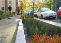
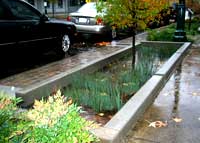
 Green Streets Portland, Oregon
 Trigger
1. Manage stormwater runoff both at the source and the surface.
2. Use plants and soil to slow, filter, cleanse, and infiltrate runoff.
3. Design facilities that aesthetically enhance the community.
Effect
* traffic calming
* increases livability
* increases community involvement
Other Benefits
* recharges groundwater supply
* stormwater harvesting for reuse
* reduces runoff volume
* cleans automobile drips of hydrocarbons and other pollutens (bioremediation)
* stores large volume of water
Managing stormwater runoff from the street through vegetated planters for flow and water quality benefit. A green street retrofit which manages stormwater at the source through a vegetated swale, while enhancing the neighborhood.
Stormwater Facility Science
The surface area of a typical stormwater facility allows runoff to pond and evaporate while sediments settle into a layer of mulch. The organic mulch layer prevents soil bed erosion and retains moisture for plant roots. It also provides a medium for biological growth and the decomposition or decay of organic matter. The soil stores water and nutrients to support plant life. Worms and other soil organisms are very good at degrading organic pollutants, like petroleum-based compounds. They also help mix organic material, increase aeration,
and improve water infiltration and water holding capacity. Bacteria and other beneficial soil microbes process the majority of pollutants, including most of the nitrogen. The stiff structure of plants such as rushes and sedges slows water passage and traps sediments within the surface area of the facility.

Mt Tabor Middle School
This summer, the City will build stormwater management facilities at the school and on SE 57th Avenue just south of Pine Street. The project will feature a raingarden, infiltration planters, and a stormwater curb extension. Over the last year, Environmental Services has worked closely with Portland Public Schools and the Portland Office of Transportation to design these facilities. The new systems will dramatically reduce the amount of runoff draining to the sewer, and reduce the risk of sewer backups in homes on Pine Street. These attractive facilities
are designed to improve the school grounds and the urban environment, in addition to managing runoff.
SW Hillsdale
Construction is completed on two water quality planters in downtown Hillsdale in southwest Portland. The planters will treat stormwater runoff from 20,000 square feet of SW Capitol Highway. Runoff will enter the planters through curb openings and filter through soil to remove pollutants. The filtered water will flow into a storm sewer that drains to Fanno Creek. Each planter will have shrubs to improve their appearance, provide root structure to help maintain soil infiltration, and create habitat for soil organisms that help break down pollutants. The City will evaluate these planters, along with another design installed at New Columbia in north Portland, for potential use at other locations.
SW Texas
This summer, the City will build stormwater facilities along SW Texas Street to treat, detain and dispose of drainage from 17-acres bounded by SW California Street, SW Nevada Court, SW Capitol Highway, and SW 26th Avenue. The project will consist of a combination of conventional
stormwater conveyance systems and stormwater swales to manage runoff from roofs, driveways, and streets.
This project is the City’s response to a citizen-led initiative. This flexible, innovative project meets the needs of the neighborhood,helps meet regulatory requirements, and improves quality of life. The completed green street improvements will direct runoff away from homes and backyards, alleviate basement flooding, and reduce street erosion. The project will also protect
the City’s sewer infrastructure by managing stormwater that contributed to problems downstream in the Burlingame sewer.
NE Fremont and 131st Place
This project is the first in Portland to manage street runoff and accommodate a ramp crossing for pedestrian safety. The City removed 400 square feet of asphalt on either side of the pedestrian ramp and installed a variety of plants. Stormwater enters the vegetated area on the
west side through a curb cut and flows under the ramp to the vegetated area on the east side. The soil and vegetation slow runoff flow, filter sediments and pollutants, and allow the stormwater to soak into the ground, which reduces the burden on the combined sewer system and recharges groundwater. This was a collaborative project between Environmental Services and the Portland Office of Transportation. The two bureaus will team up on future projects to manage stormwater runoff, protect pedestrians and increase neighborhood livability.
Housekeeping
Maintenance Policy Development
Because the number of Portland green streets is increasing, the City is drafting a formal green street maintenance policy to ensure facilities have long, productive lives and to let property owners and neighbors know what their responsibilities are. The main responsibility is simple maintenance. Neighbors and property owners should keep litter, brush and trees out of the green street facility, and shouldn’t stack or store anything in it. All other maintenance will be conducted by the City.
Owners would be responsible for items needed to maintain the facilities such as yard debris bags
and tools. The draft policy also recommends sending regular green street update letters or flyers to property owners and neighbors. The City wants to make sure that as new neighbors move in, they learn about their neighborhood green street and their maintenance responsibilities. We also want neighbors to know when city scheduled maintenance has occurred at a facility.
Testing
Gathering performance information on green streets and other stormwater management facilities is an important part of Portland’s Sustainable Stormwater Management Program. The City uses the information to determine which designs work best in specific locations to help plan and design new green street projects. So far, the City has tested the NE 35th and Siskiyou green street and the Glencoe Rain Garden. Tests at NE 35th and Siskiyou show the facility
cuts peak stormwater flows to the sewer system by an average 85% and that it captures and infiltrates all the stormwater during most rain events. The test shows the facility is effectively doing what it was designed to do, reduce residential basement flooding.
The City built the Glencoe Rain Garden at SE 51st and Morrison in response to a severe basement sewer backup problem on a residential street. Stormwater runoff from 35,000 square feet of asphalt flows into the rain garden. The facility captures all the runoff from small rain events and it reduces peak flows by an average 80%. Tests on green streets at SE 56th and Ankeny and SW 12th and Montgomery showed both facilities are meeting expectations. The tests also indicated the need for some simple design modifications to make the facilities more effective. This spring, the City will do more tests including the stormwater curb extension
at NE 131st and Fremont.
References
*images above from SW 12th Avenue Green Street Project, Portland, Oregon
Kevin Robert Perry, ASLA, Sustainable Stormwater Management Program, City of Portland, Oregon
http://www.asla.org/awards/2006/06winners/
Environmental Services City of Portland, Green Street News Projects around the city
Green Streets Tour Map
Landscape- Sustainable South Bronx: Green Roofs

Green Roofs:
A green roof system is an extension of the existing roof which involves a high quality water proofing and root repellent system, a drainage system, filter cloth, a lightweight growing medium and plants.
 Green roof systems may be modular, with drainage layers, filter cloth, growing media and plants already prepared in movable, interlocking grids, or, each component of the system may be installed separately.Green roof development involves the creation of "contained" green space on top of a human-made structure. This green space could be below, at or above grade, but in all cases the plants are not planted in the "ground'. Green roofs can provide a wide range of public and private benefits.
"Heat Island Effect":
 Heat absorbency by roofs and pavement, air conditioner use, and the power plants that supply electricity for them help to create what is known as the Urban Heat Island Effect. This can exacerbate certain health conditions, and lead to more air conditioner use in a vicious cycle that costs government and individuals money. About 20% of NYC’s surface area is covered by non reflective roofs, so there is plenty of room to work with.
Benefits:
Temperature Reduction and Energy Conservation:
Reduced cooling costs by keeping the heat off the building and increasing the amount of insulation. Improved longevity for the roof by minimizing wide temperature fluctuations and exposure to the elements.
Stormwater Management:

Green Roofs provide a way to prevent overflows by absorbing and holding onto the majority of water that falls on them during a typical rain. This water is then slowly released from the soil and into the atmosphere through the foliage – in a process called transevaporation.
Improved Air Quaility:
The amount of Oxygen produced by one tree with a 16 foot diameter canopy is equaled by the amount of Oxygen produced by a 16 square feet patch of green roof with 15 in. high foliage.
In NYC, it costs over $1000 to plant a small tree that takes years to grow that big, but it costs far less to build 16 square feet of green roofs today.
Vegetative surfaces also trap harmful airborne particulates and keep them from entering our lungs, and can dampen noise pollution too. Pollutants in the air are less harmful under lower temperatures that these roofs maintain.
Cost:
Retrofitting and existing building with a green roof costs more than a conventional roof, but this investment yields cost savings over time through energy conservation and rooftop longevity. A green roof can also increase the resale or rental value of a property, as well as provide aesthetic enjoyment for you in the meantime.
http://www.youtube.com/watch?v=sslD7H6ruMM
Sustainable South Bronx:
Founded in 2001 by life-long South Bronx resident, Dr. Majora Carter, SSBx addresses land-use, energy, transportation, water & waste policy, and education to advance the environmental and economic rebirth of the South Bronx, and inspire solutions in areas like it across the nation and around the world.
Landscape- CityTrees
CityTrees is a volunteer-based non-profit organization improving the environment and building community in Redwood City through a coordinated program of tree planting, pruning, and education. CityTrees works in close conjunction with the City of Redwood City Public Works Services Department. Since 2000, CityTrees has planted over 1,800 new trees in Redwood City. Our pruning program helps ensure the young trees we plant grow strong and healthy.
CityTrees raises funds for the purchase and maintenance of trees through grants, local business sponsorship, and individual memberships and contributions. CityTrees also recruits volunteers from the community to plant and maintain trees, and has established a number of ongoing partnerships with service groups and businesses.
The community organization of CityTrees could provide a solid foundation for community development while increasing Denver's Arboreal Infrastructure (see Ron Henderson above).
Their history http://www.citytrees.org/planting_history.html
Resources.
http://www.citytrees.org
April 12, 2008
Landscape- Las Gaviotas/ what can I do?
The eco-village known as Las Gaviotas is a research center located in eastern Colombia, South America. It is the only project in the world with a twenty-three year track record of the sustainable regeneration of tropical rain forest. As of this year, las Gaviotas will have successfully reforested 8,000 hectares (20,000 acres) of fully canopied, poly-culture rain forest.
The results of this success are many. They include:
• Pure drinking water.
• 10% increase in annual rainfall.
• Dramatically decreased surface soil temperatures.
• Net cooling effect.
• Sustainable living wage economy for indigenous population.
• Development and use of alternative sources of energy.
• Proliferation of plant species, 253 at last count and rising.
• Sustainable sources of lumber, resin, cashew and bio-fuels.
• Sensible and sustainable management of natural resources.
• A model for sustainable third world rural development.
As a result of this success, Las Gaviotas has 144,000 tons of carbon offsets to offer on an annual basis. This tonnage of annual carbon sequestration is calculated using formulas developed in response to the Kyoto Treaty on Global Warming known as the Kyoto Protocol. The 8,000 hectares of existing maturing tropical rain forest is the source for this annual tonnage of carbon offsets.
90% of all donations received by the Marion Institute in support of this initiative will pass through directly to ZERI Eje Cafetero in Colombia to fund the planting regimen and related research at Las Gaviotas. 10% of the funds will remain with the Marion Institute to cover the costs of administering the program and to fund the ZERI Learning Initiative. The ZERI learning Initiative is devoted to the training of teachers in how to teach systems thinking and sustainability to K-12 age school children throughout the US.
www.zeri.org
www.marioninstitute.org
Landscape- Arboreal Infrastructure
ARBOREAL INFRASTRUCTURE
Sustainable Technologies for Urban Transformation
Balancing systems for an ecological urban transformation
key words: ecological infrastructure
urban forest
landscape urbanism
In the middle of our life's path I found myself in a dark forest, where the straight line was lost. (Dante, Inferno 1:1-3)
INFRASTRUCTURE IS NATURE
Ecological infrastructures, such as aquatic and arboreal systems, are insidious agents in urban -regional territories. These infrastructures are dynamic fields of biology and metabolism that are inhabited by human and non-human ecosystems alike.
NATURE IS ARTIFICE
One of these, the urban forest - or what could be called Arboreal Infrastructure - is the matrix of urban forest that is, worldwide, the most rapidly expanding forest of all. As global cities expand, they inherit edge conditions that are more densely forested than the historic city centers so the percentage of forest cover increases. Additionally, municipalities such as Beijing and Chicago have aggressively acted to enlarge the arboreal infrastructure of their metropolitan regions. Beijing has planted over 30 million trees in the past ten years. Chicago has planted fewer, but these are strategically located as part of the transportation infrastructure - the largest and most "everyday" of the more traditional communication and transportation infrastructures.
ARTIFICE IS ECOLOGY
The mechanism for the expansion of these urban forests are national and municipal policy initiatives that quantify the tree canopy coverage as a percent of the total land area of these municipalities. Twenty five percent tree canopy coverage has been identified by the United States Department of Agriculture as a threshold at which significant ecological benefits are produced from the urban forest. In a small city such as Providence, Rhode Island (population 180,000) the increase in canopy from 18% to 25% will require the planting of a flock of 37,000 trees. Beijing recently announced that it had achieved the 50% tree canopy coverage it promised the International Olympic Committee prior to the 2008 Olympic Games.
A brief history of the transformation of urban tree planting from agricultural plot to microclimate enhancements to delineators of urban space will be reviewed with a conclusion outlining current shifts in urban forest policies from beautification to ecology as the basis for the planting and management of the urban forest. Advances in the technology of arboriculture will augment this review and amplify the artifice of ecology in the urban forest.
Ron Henderson is a landscape architect based in Providence, Rhode Island USA. He is Visiting Associate Professor and Director of Graduate Landscape Architecture Design Studios in the newly established Department of Landscape Architecture at Tsinghua University, Beijing PRC. He is also Visiting Assistant Professor of Architecture at Roger Williams University, Rhode Island USA and founding principal of L+A Landscape Architecture. He directs a policy initiative, Arboreal Infrastructure, that coordinates national, state, municipal, academic, non-government organizations, and professionals that has resulted in the drafting, review, and adoption of one of the most advanced ecological municipal landscape ordinances in the United States.
1500 bc fresco of garden high official's tomb trees, orchards, palms, groves, vineyard, pools, birds, pavilions, .... already the components of all gardens of all times were already represented. (Vercelloni, 1990) repetition - groves and orchards - not individual plants (Far Eastern)
15C Milan Filarete's Sforzinda palace-garden (Vercelloni, 1990, pl. 28) roof garden rather than a garden BESIDE the palace
Jacopo De'Barari's bird's eye view of Venice coincide with those shown on Francesco Colonna's Hypnerotomachia Poliphili, published by Also Manuzion a year earlier in 1499. The walled gardens are tended but the public realm is less tended and wild. (Vercelloni, 1990, pl.31)
June 29, 1545, the Senate of the Serennissima Repubblica di San Marco decreed the establishment of the first botanical garden in Europe, in Padua, on the Venetian mainland. 1,168 species classified in beds using monastic wisdom and recent scientific knowledge. (Vercelloni, 1990, pl. 39)
Jacques Androuet de Cerceau' Les plus excellents bastiments de France (Vercelloni, 1990, pl. 43) extroverted garden
what is the difference between gardens, parks, and forests JDHunt first second and third nature
Gabriel Thouin, 1820, published a tableau in his treatise on gardens. These might also record the various classifications of arboreal use: economy, agriculture, botanical, pleasure. Do we now add ecology ? (Vercelloni, 1990, pl.166)
"This isn't yours," he repeated, "because it's the ground that's yours, and if I put a foot on it I would be trespassing. But up here, I can go wherever I like." Baron in the Trees, p. 19
Trees seem almost to have no right here since my brother left them or since men have been swept by this frenzy for the ax. And the species have changed too; no longer are there ilexes, elms, oaks; nowadays Africa, Australia, the Americas, the Indies, reach out roots and branches as far as here. What old trees exist are tucked away on the heights; olives on the hills, pines and chestnuts in the mountain woods; the coast down below is a red Australia of eucalyptus, of swollen India rubber trees, huge and isolated garden growths, and the whole of the rest is palms, with their scraggy tufts, inhospitable trees from the desert. Baron in the Trees, p.17
Beauty demands peace; peace depends on a new contract. Serres p.25
The only strong or concrete reason that peoples and states have found to join forces and institute a lasting truce among themselves is the formal idea of perpetual peace, an idea that has always been abstract and inconsequential because nations have been able to consider themselves, as a group, alone in the world. Nothing and nobody and no collectivity was above them, and thus no reason. >
Since the death of God, all we have left is war. >
But now that the world itself is entering into a natural contract with the assembled peoples, however conflicted their assembly may be, it gives the reason for peace, as well as the sought after transcendence. >
We must decide on peace among ourselves to protect the world, and peace with the world to protect ourselves. Serres, p. 25
Most of Toronto's ravine parks run north-south and lack the east-west connections that could allow animals to move from watershed to watershed. The land included in the existing parks is also often steeply sloping; there are few good examples of upland areas that include interior spaces protected from obvious human disturbances, such as trampling. Downsview offers a rare opportunity to establish protected interior habitat and to simultaneously connect two north-south ravine systems (the Don and the Humber River systems). With careful spatial strategies in design and management, this infrastructure could be built to support biodiversity while encouraging humans to enjoy social recreation. it is not an "either/or" choice but rather a matter of establishing an informed basis to achieve "both/and." The basic idea is not new, but I believe that explicitly creating an infrastructure that supports regional biodiversity on a site-by-site basis while recognizing cumulative effects would be a new goal for urban design. (Hill, in Downsview, p 98)
Infrastructure is a prevalent term among the Downsview projects that can be posited as an operation, architecture and landscape are both understood as originary conditions in an urban environment, where a natural or real ground no longer exists. According to this point of view, the notion of infrastructure challenges the idea of a seamless, naturalistic, or naturalized surface that blurs particularities and differences, by making visible the graft that joins landscape to architecture, opening both toward a new definition of urban space. (Pollak, Downsview, p.45)
Tree Ecology. The designer is wise to respect certain ecological relationships among trees. Trees associated in nature have a more comfortable appearance when used together; they are usually complimentary in color and texture, and have similar cultivation requirements. When they are used together maintenance is obviously simpler than when trees with different moisture and soil requirements are grouped. (Zion, p.83)
The potential of trees in shaping and humanizing cities remains an unperceived amelioration for a civilization that has nearly forgotten the relevance of art in civic design. paradoxically, the opportunity to use trees as part of the city has been impeded by confusing the intrinsic characteristics of the forest and the city. Current urban planting design tries to represent the way trees grow in nature. This is our inheritance from the nineteenth century. The proper use of trees in cities should reinforce the structure of the city according to the disciplines of urban design, not plant ecology. Unity, continuity and scale have more consequence than natural history in weaving together the diverse threads of the urban fabric. The civic designer, like the artist and craftsman, expresses his understanding of nature not by copying but by creating an interpretation of our elusive relationship with the organic world. (Arnold, p.41)
ARBOR-, SILVA-, AND FOREST
The word 'forest' comes from the Latin 'foris,' which means outdoors or away from civilization. Forest shares an etymological root with "forum," an outside place.
-sen, -lin
Early Urban Forests
http://www1.brcc.edu/murray/Urban_Forestry/module/overview/A102a.htm
Difficulties Studying Early Urban Forests
The history of urban forestry is difficult to document by conventional research techniques. The green infrastructure of urban areas does not preserve as well as the gray infrastructure and archeologists are not actively searching to uncover evidence of ancient landscapes. Urban forests are not as well documented in literature and historical documents. Since a significant portion of early urban forests existed in open space, they were probably then, as they are now, sacrificed to make way for urban sprawl.
Reasons for Early Urban Forests
As early as 2,000 - 3,000 BC, Egyptians were lining ceremonial routes with trees. Around the fifth century BC, Athenians installed public gardens and street trees in their city and maintained them with elaborate irrigation and drainage systems (Hyams, 1971). Roman emperors had trees planted along routes in cities to make it easier for troops to navigate through urban areas. Kublai Kahn mandated the planting of trees along major urban routes so his armies could still follow the assigned routes during sand and snow storms.
Hyams, E. 1971. A History Of Gardens And Gardening. New York: Praeger Publishers
Antwerp
Prior to, and during, the Middle Ages, some cities set aside open areas for military exercises and citizen enjoyment. No evidence exists that any attempt was made to landscape these open areas. The city of Antwerp undertook two aggressive tree planting initiatives during the Middle Ages (mid- to late-1500s) making them one of the earliest pioneer cities in urban forestry. Antwerp’s first urban forest consisted of a landscape that was designed and installed along public walks and gardens just within the fortified walls of the city (Girouard, 1985). This new urban forest became very popular and attracted wealthy merchants that purchased adjacent land in order to build their homes around the gardens. During the same time period, Antwerp accommodated their citizens with a second tree planting initiative along a series of elevated earthworks (ramparts) built as fortifications during the Renaissance. The city planted a triple row of trees that shaded the citizens as they strolled along the old fortifications and enjoyed the views and fresh air turning these old fortifications into tree-lined boulevards (Girourard, 1985).
Paris
Paris improved upon Antwerp’s boulevard concept with an extensive planting of elm trees along an avenue called Cours La Reine. Instead of landscaping an existing open space associated with the city’s fortifications, the Parisians planted trees along existing avenues, creating some of the earliest tree-lined avenues. The primary purpose of these tree-lined avenues was for socialization. Wealthy citizens dressed up and rode in their ornate carriages while others, on foot, promenaded under the shade of the elm trees. In addition to the social spectacle, citizens enjoyed a view of the Seine river, fresh air, and cooler temperatures.
Girouard, M. 1985. Cities And People: A Social And Architectural History. New Haven, CT: Yale University Press
Evolution of the Tree-lined Boulevards
Raised earthen ramparts were usually built as a defensive structure and served as a boundary between the city and country. Trees may have been planted on the ramparts to help conceal the location of the town and to strengthen the embankment against cannon fire. Influenced by the tree-lined ramparts of Antwerp and the Cours La Reine, Parisians performed an extensive tree planting initiative on ramparts around Paris in the 1670s (Girouard, 1985). At this time, warfare with cannon artillery had evolved making the city’s ramparts no longer effective as defensive barriers. The trees were planted on the ramparts in four rows to create a central drive for carriages and two sidewalks for pedestrians. These tree-lined boulevards eventually became connected and experienced an increasing volume of traffic. Citizens preferred traveling along the shaded boulevards instead of the congested, noisy, treeless streets of the inner-city. By the late eighteenth century, tree-lined boulevards were spreading across France and Europe and the term boulevard was no longer associated with ramparts of fortifications.
During the eighteenth century, the French improved the tree-lined boulevards and avenues and demonstrated how trees could be planted in uniform rows to establish spatial boundaries (Kostoff, 1991). Napoleon also helped to shape the urban landscape around this time by widening all of the major avenues to decrease the opportunity for protestors and invading forces to erect roadblocks. Napoleon propagated these wide tree-lined boulevards in countries that he conquered.
Influential designers in the mid-eighteenth century, like Andre Le Notre, were routinely planting multiple rows of trees along major avenues in Paris to achieve an architectural goal of structural space (Kostoff, 1991). The incorporation of tree-lined avenues soon became an established practice in urban design and continues today.
Girouard, M. 1985. Cities And People: A Social And Architectural History. New Haven, CT: Yale University Press
Kostof, S. 1991. The City Shaped: Urban Patterns and Meanings Through History. Boston: Little, Brown and Company
History of Urban Forests in American
Due to the haphazard growth of Jamestown there was no attempt by the early settlers to plan for landscaped areas. In fact, the citizens were slow to even plant gardens since they were preoccupied with the more profitable practice of raising cattle and tobacco. The Virginia Company had to pass a law in 1629 requiring the Jamestown settlers to plant gardens (Hyams, 1971). Williamsburg’s layout was probably influenced by European urban design so that in addition to broad, straight streets there were also open spaces (Brinkley and Chappell, 1996). These open spaces, or village greens, were at the center of colonial villages in New England and used by the local militia for mustering and drilling and by the local residents as a common pasture for livestock and horses. By the late eighteenth century trees were planted in village greens and along streets. Early American cities, like British cities, had tree-lined streets in residential areas but not in city centers. Kostoff (1991) recognizes a distinction between avenues, which were primary traffic streets, and boulevards, which were broad, straight roads with landscaped medians. Boulevards were often located around the periphery of cities and used to connect parks. As in Paris, vehicular traffic eventually took over the boulevards for rapid transport across cities to avoid congested city streets.
The French tree-lined avenue influence was evident in Pierre Charles L’Enfant’s design for Washington, D.C. L’Enfant purposefully designed broad avenues to facilitate the planting of trees and open spaces for monuments and for use by the public. In 1869, two influential landscape architects, Frederick Law Olmstead and Calvin Vaux, famed designers of Central Park in New York City, increased the public’s awareness of tree-lined streets in residential areas with their design of Riverside, Illinois. Olmstead and Vaux purposely designed and insisted on the installation of thousands of trees along the curved streets of one of America’s earliest planned suburban residential neighborhoods. It’s important to note that Olmstead and Vaux scaled their design for pedestrians – not vehicles (Kunstler, 1993). Sadly, as long as vehicles rule the residential roads, we will not be able to experience the vistas and other experiences designers such as Olmstead intended around our homes and communities.
Brinkley & Chappell, 1996.....
Hyams, E. 1971. A History Of Gardens And Gardening. New York: Praeger Publishers
Kostof, S. 1991. The City Shaped: Urban Patterns and Meanings Through History. Boston: Little, Brown and Company
Kunstler, J.H. 1993. The Geography Of Nowhere: The Rise and Decline Of America’s Man-Made Landscape. New York: Simon & Schuster
Federal and State Involvement
Before the economic and ecological benefits of urban forests were known, tree planting was performed as a part of a beautification effort to block undesirable views. In the early and mid-1950s, landscape architects often used trees to create the perception of open space since available space was being rapidly developed to support increasing urban populations. It should come as no surprise that the origins of the federal urban and community forestry assistance grant program was rooted in the perceived need to beautify urban areas. President Johnson initiated a task force on natural beauty and one member of this task force, Whyte (1965), proposed a landscape-townscape program that was eventually included as a provision in the Housing Act of 1965. The Department of Housing and Urban Development modified Whyte’s original provision and titled it “Urban Beautification.” This program provided 50 percent matching grants for landscaping and beautification efforts for communities. This money went directly to local governments, bypassing state governments. In 1978, Congress recognized that urban forests improve the quality of life for residents and that the health or urban forests were on the decline. The Congress passed the Cooperative Forestry Assistance Act to provide financial and technical assistance to improve urban forests across the United States.
Current State of Urban Forests Across the United States
In order to determine if urban forests are increasing or decreasing across the United States an accurate baseline must first be established. Using satellite imagery, high-altitude photography, and computer software (CITYgreen) American Forests has been able to document a change in tree cover over urban areas across the United States. CITYgreen software generates a detailed inventory of vegetation by combining the images and photographs with available field data. In Washington, D.C., American Forests calculated the heavy canopy cover (acreage with 50% or more tree cover) and discovered that between 1973 and 1997 there was a loss of 64 percent (American Forests, undated). Based on a survey of 20 cities, a third of the cities only planted one tree for every eight removed, and about half of the cities faired slightly better by planting one tree for every four removed (Moll, 1987).
Moll, G. 1987. The State of Our Urban Forests. American Forests May/June.
Whyte, W.H. 1968. The Last Landscape. Garden City, NY: Doubleday & Company, Inc.
Bibliography
Arnold, Henry, Trees in Urban Design, New York: Van Nostrand Reinhold Company, 1993
Calvino, The Baron in the Trees. Translated by Archibald Colquhoun, New York: Harcourt Brace & Company, 1959
Harrison, Robert Pogue, Forests, the Shadow of Civilization, Chicago: The University of Chicago Press, 1992
Hill, Kristina, "Urban Ecologies: Biodiversity and Urban Design," in Julia Czerniak, Case: Downsview Park Toronto, Munich: Prestel, 2001
Pollak, Linda, "Building City Landscape: Interdisciplinary Design Work in the Downsview Park Competition," in Julia Czerniak, Case: Downsview Park Toronto, Munich: Prestel, 2001
Sauer, Leslie Jones, The Once and Future Forest, Washington D.C.: Island Press, 1998
Serres, Michel, The Natural Contract. Translated by Elizabeth MacArthur and William Paulson, Ann Arbor: The University of Michigan Press, 1995
Vercelloni, Virgilio, European Gardens: An Historical Atlas, New York: Rizzoli, 1990
Vico, Giambattista, The New Science. Translated by T.G. Bergin and M.H. Fisch. Ithaca: Cornell University Press, 1968
Zion, Robert, Trees for Architecture and the Landscape, New York: Van Nostrand Reinhold Company, 1968
CCTV 12 March 2006 6:30 pm report:
CHINA
-12 billion trees planted in China in past 5 years
- in 2005, 3.79 million hectares planted
- nationwide, 18.21 canopy coverage
BEIJING
-50% canopy coverage in Beijing achieved - as promised to IOC
How does one walk in a straight line through a forest ? rph p.113
not just enough to imagine the rational consequences of the urban forest - the mystery of Vico's giants of the Grimm Brothers must present itself in the rationality of the street tree.
p.211 rph forests cannot be owned
The only true shelter on earth is the earth itself. rph 234
Arboreal infrastructure and the accomplishments Wangari Maathai. Arboreal Infrastructure has been endorsed as an agent of Peace.
Do trees equal peace ?
ARBOREAL INFRASTRUCTURE
How does one walk in a straight line through a forest ? The mind's eye immediately conjures a dense forest, Bavaria or Virginia perhaps. Yet these forests are in decline in quality and quantity globally.
In the United States, the only forest that is growing is the urban forest. Suburbanization and mineral extraction are reducing the area of the forests. Climatic shifts and pollution of many sorts are degrading the forests that remain. Yet, in cities as diverse as Beijing (population 15.0 million) Chicago (population 2.5 million) and Providence (population 180,000) the urban forest is being expanded.
As a significant component of a comprehensive analysis of urban ecological systems, the urban forest
No one has ever won the Nobel Peace Prize for building a structure, but they have won for planting a tree.
4. URBAN FOREST TERMS
1. 1. All trees and other vegetation in and around dense human settlements. http://hermes.richmond.edu/urbanforests/glossary.html
2. 2. Created where people congregate and build communities. Since humans are the main inhabitants of the urban forest, they largely determine the tree species in this forest. http://www.lpb.org/programs/forest/glossary.html
3. 3. For the purposes of micro-climate regulation, aesthetic value and water absorption, certain area shall be designated as urban forest. http://www2.bonet.co.id/dephut/41-99-1.htm
4. 4. Forests in, next to or nearby a specific urban area, of which the decision-making processes on desirable functions are dominated by local actors and their objectives, resulting from their perceptions, norms and values. Urban forestry is believed to differ structurally from forestry at large in terms of the geographical location, structure and ownership of the forested area, as well as in terms of the density of (recreation) facilities, actors involved in policy-making, major uses, policy instruments and the occurrence of social conflicts and dynamics of policy processes. http://www.efi.fi/publications/Working_Papers/12.html
5. 5. The approach was to use an urban forest concept with the concept of the 20-20 rule. The 20-20 rule referred to development sites preserving 20% of total lot planting area and 20 trees per acre being required as a measurement of urban forest. http://www.cityofdenton.com/council/minutes/021798.html
6. 6. The term we use for ALL the trees and woods within the Black Country. http://www.nufu.org.uk/htmfiles/bcuf.html
7. 7. The sum total of all vegetation growing in urban areas - www1.br.cc.va.us/.../module/ overview/A101a.htm
8. 8. The trees, forests, and associated organisms that grow near buildings and in gardens, green spaces, parks and golf courses located in village, town, suburban, and urban areas http://www.forestry.utoronto.ca/ac_staff/emeritus/My%20Webs/english.htm
9. 9. The trees, woodlands, woody shrubs, ground vegetation and associated green space within the urban environment http://www.susdev.gov.mb.ca/wildlife/misc/glossary.html
10. 10. The vast supply of recyclable paper produced in our cities, particularly office paper, represents a considerable untapped resource and has been coined the “urban forest”. http://www.foe.co.uk/camps/indpoll/paper.htm
11. 11. Urban Forest - The current EMO defines urban forest as performing several functions. Two of these functions require that an urban forest be located in the front of site along the roadway. Thus, if a site has urban forest in the rear or along the sides, the urban forest does not qualify to meet the 10 percent requirement. However, the EMO grants a credit (in the form of an increase in the percentage of the actual area preserved) if the urban forest is preserved along the front of a site. This is an obvious conflict in the EMO. Staff is proposing to correct this problem by clarifying that an urban forest may perform any one of the functions itemized in the definition, but not necessarily all of the functions. Thus, if a site has urban forest in the rear or the sides, it can qualify to meet the 10 percent requirement. The definition of urban forest also states that an urban forest is measured by using the tree drip line. The drip line of a tree represents the vertical projection (on the ground) of the outer perimeter of the crown of a tree. The problem with utilizing the drip line of a tree to measure urban forest is that measuring the drip line of a tree is not a standard technique that is typically used in the field by site designers. This measurement is also difficult to obtain for deciduous trees which lose their leaves in the fall. To correct this problem, staff is recommending that the term drip line be replace with the term "critical protection zone." The critical protection zone is a standard that is currently defined in the EMO and has been traditionally used and is accepted by site designers to comply with the EMO’s tree removal section. The critical protection zone is a circle surrounding a tree described by a radius of one foot for each inch of the diameter of the trunk of a tree. A public hearing has been scheduled to be held on May 3, 1999, before the Tallahassee-Leon County Planning Commission on Ordinance No. 99-O-0020. The Planning Commission will review the ordinance for consistency with the Tallahassee-Leon County Comprehensive Plan. http://fcn.state.fl.us/citytlh/agenda/1999/990512/29.htm
12. 12. Urban or community forestry is the planning for, and management of, a community's forest resources to enhance the quality of life. The process integrates the environmental, economic, political, historical, and social values of the community to develop a comprehensive management plan for the urban forest. A community in this definition is an area of human settlement in a rural or metropolitan region. The urban or community forest includes the vegetation, open space, and related natural resources of the area. http://www.ag.uiuc.edu/~forestry/guide/pref.html
13. 13. We simply mean all trees and shrubs growing in populated areas. http://www.dnr.state.md.us/forests/education/shed.html
Landscape- Herman Miller Parking


The Herman Miller furniture manufacturing and assembly plant is situated on a 70-acre site in rural Georgia. The project’s modest building and site budget included no provision for landscape architecture before the architects invited Michael Van Valkenburgh, Inc. (MVVA) to join the design team. The client required parking for 550 cars and 120 semi-trailers—a total area of 10 acres. Runoff from the parking surfaces, the roadway, and the roof of the 330,000 square-foot facility would have had a devastating impact on the surrounding fragile creek ecosystems. The landscape architects determined that treating and slowly releasing the massive runoff in the landscape must become an essential priority for the project.
MVVA approached the porject with a simple strategy: grade the entire 22-acre building site at 5% to place the factory on a level base, so that water would sheet drain from impervious areas into wetlands constructed for the purpose, thereby eliminating the need for curbs, pipes, and manholes. The parking lot was divided into three bays that drain into wetlands planted with grasses, forbs, and sedges. When dry, these areas become meadows. The edges of these wetland trays transition to 10 to 15-foot-wide thickets of floodplain tress.
Using hydrologic management as an engine of this project’s design, the landscape architects extend Olmsted’s lineage with hydrologic systems to a new project type: the rural factory. We showed the client how to redirect money from the engineer’s budget and use grading, planting, environmental stewardship, and site organization to integrate storm water management into a vast factory system. In our scheme, parking became part of a thriving ecological system that neutralizes the impacts of runoff, provides habitat for wildlife, and offers a compelling arrival and departure experience to the three-shift factory’s employees.
By integrating ecology into acres of hardscape in an honest, elegant manner, this project creates a new model for low-cost, low-maintenance, environmentally sound factory landscapes. This model could be applied with equal success in suburban and urban areas and demonstrates how landscape architects can take a lead in linking effective hydrological management with good design.
Subscribe to:
Posts (Atom)